


VFRnav flight navigation
توضیحات VFRnav flight navigation
VFRnav is a flight navigation application for VFR pilots.
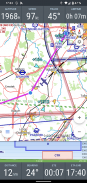
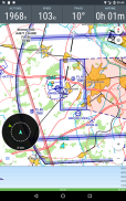
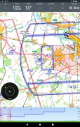
The moving map in the well known IC*O-style supports the pilot with the navigation and thus leaves time for the bright side of flighing.
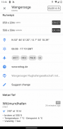
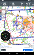
The integrated database includes over 4,500 airfields and waypoints from many european countries with information about airport names, frequency and runway information. A "double tab" on any point on the map shows this additional information.
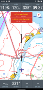
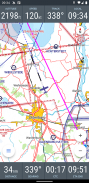
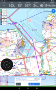
By the support of the OpenAir file format, any airspaces (including gliding sectors) can be shown on the map.
Especially helpful: After downloading the desired maps (completely free) as well as the airspace files, VFRnav works completely offline and does not require an existing data connection at any time. Not even a SIM must be available in your smartphone. (Advise: For optimal battery life it is recommended to switch on the flight mode during your trip)
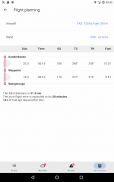
With the track recording feature you can track any flights. Tracks can be exported as KML files and/or sent by e-mail . Flown routes can be shown on Google Earth. The flight time recording also automatically records time and place of takeoff and landing and calculates the time of flight.
The development of VFRnav is made in close contact with the users. We set a high value on the intuitive use and usability as well as an Android typical app-design. In the current second version many ideas and suggestions have been implemented which have reached us in the past few months by e-mail. Thank you at this point for the extensive feedback.
The basic functions of VFRnav can be tested without any time limitation. If you like VFRnav, you can purchase a license for currently 49,95 Euros. This will give you free updates for one year. After the 12 months a lower priced update license can be purchased. VFRnav itself can be used unlimited.
By the way: The license is personal but not linked to any specific device. If you use multiple Android devices with the same Google account, your license is valid on all your devices.
Requirements: For the real time air navigation a device with GPS is required. Furthermore your smartphone or tablet needs at least 200 MB of free space. VFRnav has been tested on Android 2.2 up to 6.0 (Marshmallow) . A minimum display resolution of 480x800 pixels is recommended.
If you have any questions do not hesitate to contact us by e-mail.
Disclaimer: Please note that VFRnav is not an officially approved aid for the flight preparation and air navigation. A guarantee for the correctness and completeness of data cannot be given. We are not responsible for any use of this application. Please check the data displayed always with official maps of aviation.
VFRnav est une application de navigation aérienne pour les pilotes VFR.
</div> <div jsname="WJz9Hc" style="display:none">VFRnav is een vlucht navigatie-applicatie voor VFR piloten.
De bewegende kaart in de bekende IC * O-stijl ondersteunt de pilot met de navigatie en laat dus tijd voor de zonnige kant van flighing.
De geïntegreerde database bevat meer dan 4500 vliegvelden en waypoints uit vele Europese landen met informatie over het vliegveld namen, frequentie en informatie landingsbaan. Een "dubbele tab" op een willekeurig punt op de kaart toont deze aanvullende informatie.
Door de steun van de OpenAir bestandsformaat, kan elke luchtruimen (waaronder zweefvliegen sectoren) worden op de kaart weergegeven.
Vooral nuttig: Na het downloaden van de gewenste kaarten (helemaal gratis) evenals het luchtruim bestanden, VFRnav werkt volledig offline en niet een bestaande dataverbinding op elk moment nodig. Niet eens een SIM moet beschikbaar zijn in uw smartphone. (Advies: Voor een optimale levensduur van de batterijen is het raadzaam over te schakelen op de flight mode tijdens uw reis)
Met de track recording functie kunt u vluchten volgen. Tracks kunnen worden geëxporteerd als KML-bestanden en / of per e-mail. Gevlogen routes kunnen worden weergegeven op Google Earth. De vlucht tijdregistratie ook registreert automatisch tijd en plaats van opstijgen en landen en berekent de tijd van de vlucht.
De ontwikkeling van VFRnav is gemaakt in nauw contact met de gebruikers. We zetten een grote waarde aan het intuïtieve gebruik en de bruikbaarheid, alsmede een typische Android app-ontwerp. In de huidige tweede versie veel ideeën en suggesties zijn doorgevoerd, die ons in de afgelopen maanden via e-mail hebben bereikt. Dank u op dit punt voor de uitgebreide feedback.
De basisfuncties van VFRnav kan worden getest zonder enige beperking in de tijd. Als u wilt VFRnav, kunt u een licentie voor de momenteel 49,95 euro aanschaffen. Dit zal u gratis updates geven voor een jaar. Na de 12 maanden een goedkopere update licentie kunnen worden gekocht. VFRnav zelf kan onbeperkt worden gebruikt.
By the way: De licentie is persoonlijk, maar niet gekoppeld aan een specifiek apparaat. Als u meerdere Android-apparaten te gebruiken met dezelfde Google-account, uw licentie is geldig op al uw apparaten.
Vereisten: Voor de real-time luchtvaartnavigatiediensten een apparaat met GPS is vereist. Verder uw smartphone of tablet moet ten minste 200 MB vrije ruimte. VFRnav is getest op Android 2.2 tot en met 6.0 (Marshmallow). Een minimale schermresolutie van 480x800 pixels wordt aanbevolen.
Als u vragen heeft aarzel dan niet om ons te contacteren via e-mail.
Disclaimer: Let VFRnav is niet een officieel goedgekeurde steun voor de vluchtvoorbereiding en luchtvaart. Een garantie voor de juistheid en volledigheid van de gegevens kan niet worden gegeven. Wij zijn niet verantwoordelijk voor het gebruik van deze applicatie. Kijk dan op de display altijd met de officiële kaarten van de luchtvaart gegevens.
VFRnav est une toepassing de navigation aérienne pour les piloten VFR.</div> <div class="show-more-end">
VFRnav flight navigation - نسخه 4.8.0
(15-03-2025)VFRnav flight navigation - اطلاعات APK
نسخه APK: 4.8.0حزمة: com.flugbetrieb.VFRnav


اپلیکیشنها در دسته مشابه


